EarthCARE: ESA’s Satellite Mission to Change Our Understanding of Climate
EarthCARE: la misión satelital de la ESA que cambiará nuestra comprensión del clima.
The European Space Agency (ESA) and the Japan Aerospace Exploration Agency (JAXA) have put into orbit the EarthCARE satellite, the most advanced Earth explorer to date. The main objective of this mission is to observe and characterize clouds and aerosols, as well as to measure reflected solar radiation and infrared radiation emitted from the Earth’s surface. In May 2008, ESA signed a contract with Astrium, a subsidiary of EADS, to design, develop and integrate the EarthCARE satellite, and construction and design began in early 2009.
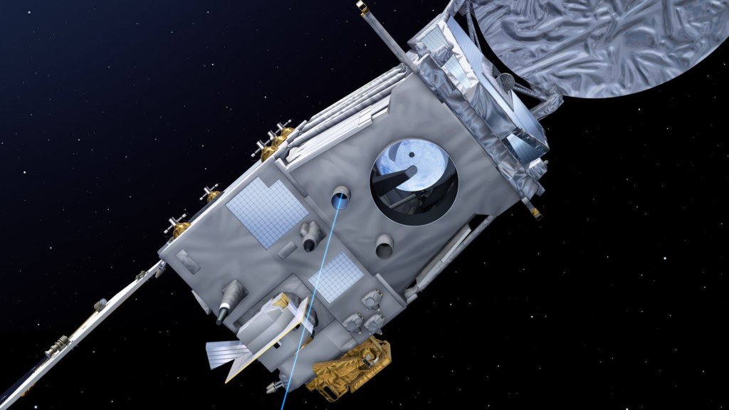
EarthCARE employs LiDAR (Light Detection and Ranging or Laser Imaging Detection and Ranging) technology and high-performance radar that has never before been flown in space. Its goal is to deliver unprecedented data sets that will allow scientists to study the relationship of clouds, aerosols and radiation with levels of precision that will significantly improve our understanding of these highly variable parameters. The EarthCARE satellite was designed and built by a consortium of more than 75 companies under Airbus, as prime contractor, and was launched on May 29, 2024 on a SpaceX Falcon 9 rocket from Vandenberg Space Force Base in California, USA.
Today, EarthCARE has completed its important ‘Launch and Early Orbit Phase’ and is ready to begin commissioning its four science instruments. The data they collect will improve our understanding of the role clouds and aerosols play in the Earth’s radiation balance and will benefit both climate modeling and weather prediction.
EarthCARE has four scientific instruments: The Atmospheric Lidar (ATLID) provides vertical profiles of aerosols and thin clouds and operates at a wavelength of 355 nm. It has a high spectral resolution receiver and a depolarization channel. The Cloud Profiling Radar (CPR) provides measurements of vertical cloud profiles and observes vertical velocities of cloud particles through Doppler measurements. It operates at 94GHz. The broadband radiometer measures reflected solar radiation and emitted infrared radiation. The multispectral imager provides an overview of the scene at multiple wavelengths.
ESA has provided a number of tools to visualize, process and analyze EarthCARE data. These data are accessible to researchers and the general public. Prior to launch, ESA and JAXA organized a pre-launch science and validation workshop for EarthCARE on November 13-17, 2023, at ESA’s Earth Observation Facility in Frascati, Italy. The workshop brought together nearly 250 participants, representing a vibrant global scientific community that is eagerly awaiting the launch of the mission.
This satellite represents a major advance in our ability to study and understand the atmospheric processes that affect the Earth’s climate. With its state-of-the-art LiDAR and radar technology, EarthCARE will provide unprecedented data sets that will significantly improve our understanding of clouds, aerosols and radiation.